When it comes to deciding when to invest your time and effort into dredging your pond, how can you make the right decision? When is it time to dredge?

Dredging is a very costly investment to improve a pond’s health, however, with the continuous development of commercial and residential areas, there are more and more sediments entering our waterways, which inevitably in up in our ponds. When this happens the ponds can become stagnant and loaded with nutrients, which can lead to harmful algae blooms and uncontrollable vegetation. Creating an overall unpleasant appearance to your pond, devaluing its purpose and benefits.
So, do you know when it is time to make the dive into having your pond dredged? How do you know what it will take to get your pond back to a state of health? What will it take to be enjoyable again?
The answer is Hydrographic and Sediment Isolation modeling.
It sounds technical, and generally is, but it is the best way to identify the amount of sediment in your pond that needs to be removed. Hydrographic mapping can be performed in several ways, the best option is to hire a reputable company with experience in these specific surveys. You may know a good land surveyor and trust them, but often you will not receive the information needed for a project in aquatics – water and land are not created equal when surveying.

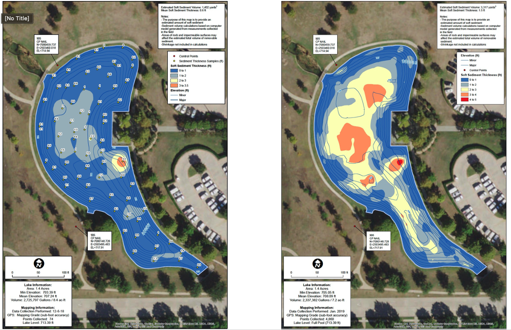
Misrepresented and inaccurate mapping manifests into inaccurate sediment volumes and dredging costs.
A proper hydrographic survey will be conducted using GPS location and high accuracy sonar equipment, as well as software designed for hydrographic surveys. This will allow the hydrographer to map the layer of sediment suspended just above the pond’s bottom that is fluid like water because it mostly is, commonly known as ‘unconsolidated sediment’. Using a manual probe, the hydrographer will be able to find the hard bottom, or ‘hard pan’, of your pond. These methods together give an accurate representation of how much sediment is in the pond or lake, as compared to how it was built, designed, and original volume to hold. Having accurate data is crucial to making accurate calculations of how much material should be removed from your pond, and ultimately how much money it will cost.
The Hydrographer will then be able to produce a series of reports about the pond’s depth, contours, sediment quantities, and where they are. Sometimes only small areas of a pond require dredging, as sediment tends to accumulate in some areas more than others. The information received from the survey may be able to specify the area requiring dredging the most and can avoid the added expense in dredging areas that do not require attention at that moment, or in the near future. The one size fits all approach (remove all the material methods) commonly taken, may not be the best for the pond and/or the situation.
If you decide that dredging is not the choice today but will be sometime in the future – That is okay! Here are some action items to consider now:
- Routine bi-yearly surveys can help prepare for your dredging project in the future: Mapping regularly allows for knowing future costs of dredging, so that budgeting and building reserves are a breeze.
- Throughout the routine surveys, you can observe the average yearly accumulation of sediment and anticipate your ‘threshold’ date; AKA when action NEEDS to be taken.